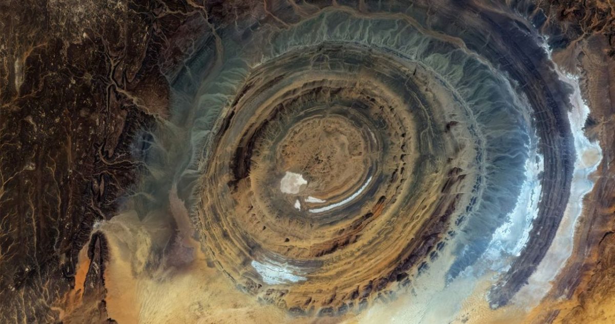
First documented in the 1930s, the Richat Structure was once described as a giant buttonhole in the desert. For decades, its concentric rings puzzled geologists and astronauts alike. Today, NASA has provided a clearer explanation for this geological phenomenon, known popularly as the Eye of the Sahara.
Geological Background of the Richat Structure
The Richat Structure is located in the Sahara Desert, near Ouadane, Mauritania. It spans roughly 40 kilometers in diameter, making it a prominent landmark visible from space. Despite its nickname, the structure is not an impact crater. Extensive field studies and satellite imagery have confirmed its sedimentary origin.
Geologists now classify it as a deeply eroded symmetrical dome. The rock layers were originally flat but were pushed upward by volcanic activity below the surface. Over millions of years, wind and water eroded the softer layers, leaving behind the more resistant ridges that form the iconic circular pattern.
NASA’s Role in Understanding the Structure
NASA’s interest in the Richat Structure dates back to the Gemini missions in the 1960s, when astronauts photographed it from orbit. Since then, satellite instruments such as the Advanced Spaceborne Thermal Emission and Reflection Radiometer, or ASTER, have provided high resolution images that reveal detailed mineral composition and erosional history.
These observations allowed scientists to determine that the structure is not a single event formation but a long term geological process. The outer rings consist of quartzite and other hard rocks, while inner rings contain softer limestone and dolomite. The central depression exposes igneous rocks, confirming the role of ancient magma intrusion.
Implications for Planetary Science
The Eye of the Sahara serves as an analog for similar circular features observed on Mars and the Moon. By understanding how terrestrial domes erode over time, researchers can better interpret remote sensing data from other planets. The structure also helps calibrate dating techniques for sedimentary rocks in arid environments.
No official timeline exists for further studies, but NASA continues to include the site in Earth observation training programs for astronauts. Ongoing satellite missions, including Landsat and Sentinel, are expected to provide additional data as resolution improves. The European Space Agency has also expressed interest in using the Richat Structure as a calibration target for future imaging spectrometers.
As remote sensing technology advances, the Eye of the Sahara will likely remain a key reference point for both terrestrial geology and planetary exploration. Its unique formation offers a natural laboratory for understanding erosion, uplift, and the long term stability of rock layers in extreme environments.